If you want to get a Yosemite high, you’ll have a great opportunity to do so if you can squeeze in a trip after Nov. 1 and before the winter snows arrive.
The Park Service is lifting the requirement of making reservations to access the park starting Nov. 1. Social distancing will still be required.
I intend to make my way up into the high country at least once if not twice in November after the pandemic and the accompanying reservation requirement made a day trip tough to nail down from the aspect of simply being allowed to get into the national park.
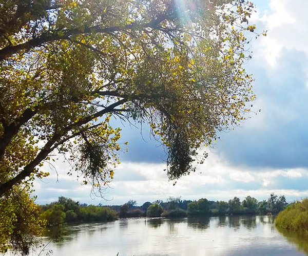
November is one of the best months to visit Yosemite Valley as the crowds thin and the colors of fall are ablaze as you get closer to Thanksgiving.
There are over 100 legitimate hiking trails covering more than 1,000 miles criss-crossing Yosemite National Park's 1,190 square miles.
Many of them are accessible from Yosemite Valley or along Tioga Road. And you don’t have to carry a three days’ supply of food and water along with camping equipment on your back to enjoy them. Many of the hikes range from easy two hour hikes to more strenuous 12-hour undertakings.
It makes a day trip from the Central Valley to hike extremely do-able.
And if you opt for the annual national parks pass that costs $80 instead of the $35 pass that is good for a week, you can enjoy a lot of Yosemite without putting a serious dent in your pocketbook. (Go to www.nps.gov/yose/ for more information.)
The only problem is that Yosemite National Park is the park that half the world seems to want to visit every year.
Yosemite Valley at times takes on the feel of communing with nature on a Los Angeles freeway or strolling down Market Street in San Francisco at high noon on a weekday. That is why between now and early December as well as early March to mid-April are the ideal times for anyone in the 209 to make their way to Yosemite Valley before the tourist invasion hits. As a bonus in the early spring, waterfalls run at their strongest. But even though the waterfalls still flowing are less vibrant there is still ample stunning scenery to enjoy. Besides, going for a day trip is a great way to break up the pandemic shut-in views and escape the smoky valley.
The high country along Tioga Pass Road — the Highway 120 segment maintained by the National Park Service — isn’t much during peak visitors seasons. The crowds are significantly smaller but still heavy enough to compromise a sense of solitude on most hikes of four hours or less.
That makes the early season along Tioga Road and in Tuolumne Meadows golden. The season starts when crews clear the road of snow. The park service doesn’t give an estimated opening until several days before the last snow is removed.
Based on weather, snowpack and previous year the odds are the high country will likely open in early May. That gives you a 30-day window to avoid nature's equivalent of Black Friday crowds.
But at the same time early November is a great time as the crowds are at their thinnest.
While there are literally dozens of hiking trails worth your time on a day trip along Tioga Road, there are six that are especially sweet.
CLOUDS REST: Let the rest of the world snake up Half Dome like ants. You get a view of not just Half Dome that is to the south and 1,100 feet lower, but a commanding view of Yosemite Valley and the high country that you rarely share with more than a handful of people if that.
It also comes without the terrifying and potential lethal drop-offs that Half Dome has except for the last 300 yards. That final 300 yards requires scrambling over a narrow spine that has drop offs of several thousand feet on each side with the longest being 4,500 feet. That said, going slow and resorting to a partial crawl gets those who are unnerved by the path to the summit and back.
The expansive 4,500-foot high face of Clouds Rest that reaches an elevation of 9,931 feet is the largest granite face in the park.
The strenuous 14-mile round trip hike starts from near Tenaya Lake and follows Sunrise Lakes for awhile. Two drawbacks to the early season hike occur early in your journey. One is the need to forge some streams where water may go above your ankles. The other is a stretch were mosquitoes put the best repellant to the test.
LOWER CATHEDRAL LAKE: This moderate 7.8-mile half-day hike starts 1.5 miles west of the Tioga Pass Road from the Tuolumne Meadows campground. It is arguably one of the most popular high elevation lakes to visit making an early season or late fall hike a must if you want to minimize encounters with other people. Along the way you get to enjoy stunning sights such as Cathedral Peak. The pristine lake at 9,300 feet is relatively shallow. Venturing three quarters of a mile from the outlet you can follow the rim of Tenaya Canyon to stunning views of relatively obscure mini lakes and mountain peaks.
POLLY DOME LAKE: It’s a fairly easy 6.2-mile round trip day hike for a readily accessible lake that very many people don’t visit. As trails go, it’s great for a beginner since you really can’t get lost. The reward is a fairly large lake surrounded by a glacier carved landscape. The trailhead is across from a picnic area on the Tioga Pass Road midway along Tenaya Lake.
EL CAPITAN: You don’t have to scale the 3,000-foot vertical granite walls to enjoy the views from the top of El Capitan. There is a 15.4-mile round trip day hike that starts at a trailhead at the Tamarack Flat campground 3 3/4 miles up Tioga Road from the Crane Flat turnoff. It is a strenuous hike that includes one major climb of nearly 2,000 feet. The views from El Capitan are worth it.
TUOLUMNE MEADOWS LOOP: It’s an easy 5.2-mile round trip hike to take in all the charms of the Tuolumne Meadows area. Do this much after the start of June — or before mid-October and the hikers will be thicker than the wild flowers. The trailhead is just west of Lambert Dome on the Tioga Pass Road.
MT. DANA: The second highest peak in Yosemite at 13,061 feet is Mt. Dana. It’s 61 feet lower than Mt. Lyell but doesn’t require mountaineering skills to conquer and is a lot shorter trek to reach. The strenuous half-day hike covering 5.8 miles starts just west of the park’s eastern entrance on Highway 120. It includes striking views of Dana Plateau with its sheer drop-offs as well as Mono Basin. From the summit of Mt. Dana you get a sweeping view of the Sierra’s spine including the largest glacier in Yosemite.
It goes without saying, you shouldn’t hike without being prepared. All but the Tuolumne Meadows hike are best done with hiking boots.
Equally important is getting an idea where you are going.
When it comes to books, there are tons of them out there. The best for my money is “Yosemite National Park: A Natural-History Guide to Yosemite and Its Trails” by Jeffrey Schaffer published by Wilderness Press. Not only does it include virtually all of the maintained trails in the park that Schaffer and his assistant personally hiked but it comes with an up-to-date map that is fairly useful.
The hike descriptions are general in nature but always include trailheads and major elements along with the highlights of what you will see.
I use the book as a base for hike planning hitting the Internet for more information. Summit Post is among the better sources, if they happen to have a hike you want to take. I typically pull up a half dozen or so Internet postings from various sites on a specific hike, compare them, and then draw up a general outline of what to look for on a hike that I carry with me such as splits in the trails.
Schaffer's book will pique your imagination. It is how I found out about my two favorite Yosemite hikes — Clouds Rest and the trek to Mt. Dana. Clouds Rest — by far my favorite thrill hike north of Mt. Whitney — has a little presence on YouTube to whet your appetite. The book’s description drove me to YouTube where I found three videos of the infamous 300-foot long spine with perilous drops on both sides. Once I saw them, I became obsessed with going. It was well worth the effort.