Oakdale Planning Commission members reviewed a proposed city boundary map at their Sept. 21 meeting that would plan the city’s growth for the next 50 years. The map is part of Stanislaus Local Agency Formation Commission’s effort to get public input on a 50-year agricultural preservation and city growth plan.
The map represents the proposed boundaries for Oakdale’s growth over the long term, possibly 50 or more years. It was part of an overall Stanislaus County Growth Management Plan that was presented to LAFCo by the Mayor’s Group at a meeting this past summer. Each city in Stanislaus County drew their desired 50-year growth area and included it on an overall map of the county. Virginia Madueno, mayor of Riverbank, presented the county map at the meeting, but emphasized that the map was very preliminary.
“It is a good way to ask cities to think about their development instead of sprawling out,” said Danelle Stylos, Director of Planning for the City of Oakdale.
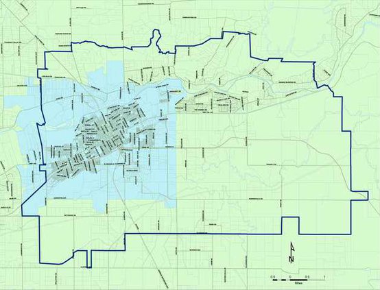
Stylos presented the latest version of Oakdale’s proposed 50-year boundary map to the Planning Commission on Wednesday. She explained that city staff is seeking input on the map and suggestions for changes before the map is presented to the Oakdale City Council on Oct. 17. Stylos said that the map is an agricultural mitigation buffer, and it sets boundaries that Oakdale agrees not to grow beyond in the long term. Every city in Stanislaus County will have a finalized map to LAFCo by the end of the year.
“The eventual goal is for the public to vote on a finalized map, but a ballot initiative has not been drafted yet,” Stylos said.
Originally, Oakdale proposed a potential city growth area that extended from current city lines in the South and East all the way to Stanislaus County lines in the North and West, covering approximately 25 percent of Stanislaus County.
“It was easier to negotiate down than ask for more. It caused a lot of lively debate among city planners,” Stylos admitted of the expansive initial proposal.
The map presented to the Planning Commission on Wednesday was a scaled down version of that original map. It includes a proposed boundary to the South at Alvarado Road. It also includes a large area of land southeast of Oakdale.
“This is tripling the size of Oakdale in 50 years…I think this is overly ambitious to say it nicely,” said commission member Tom Orvis.
Stylos said that the map is not finalized and staff can change the lines or modify the proposed growth area. Oakdale had one of the largest proposed new growth areas in Stanislaus County. Stylos said that some cities chose to stick to their current boundaries or their current general plan. Even if the map were adopted as a 50-year plan, Oakdale would not be allowed to push out to its outer edges immediately. Growth would have to be incremental, and Stylos said that the city would still be bound to its 20 year General Plan.
The proposed 50-year growth map will be presented to the city council at its regular meeting on Monday, Oct. 17. Council will seek public input on the proposed city growth and agricultural mitigation plan before a map is submitted to LAFCo.
Proposed Expansion Pushes City Boundaries