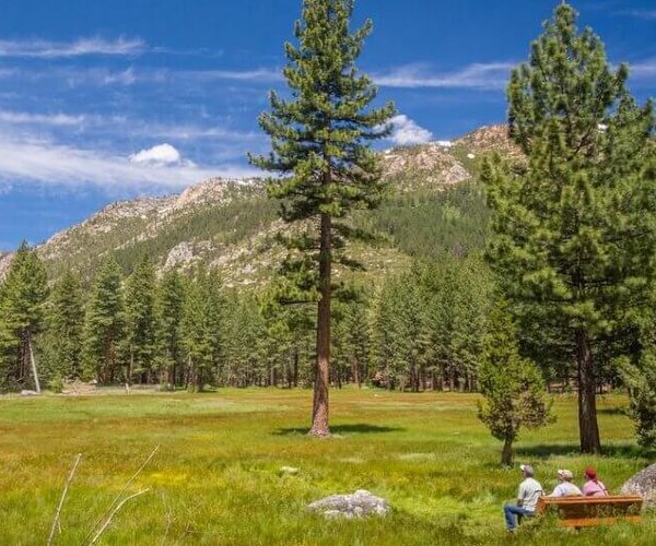

Seven miles into the Ansel Adams Wilderness I got my first view of Thousand Island Lake from the Pacific Crest Trail.
Its numerous namesake rocky islands — many complete with pine trees — broke up the gently wind whipped blue water sparkling below the 12,942-foot prominence of Mt. Banner dotted with several small glaciers.
The lake before me was unlike the 10 others I had passed as I made my way into the High Sierra from June Lake. This was the headwaters of the Middle Fork of the San Joaquin River where some of the snowmelt — if it is lucky — will make a 366 mile journey before flowing into Suisun Bay at the Delta’s edge on its way to San Francisco Bay then out the Golden Gate to mingle into oblivion with the vast waters of the Pacific Ocean.
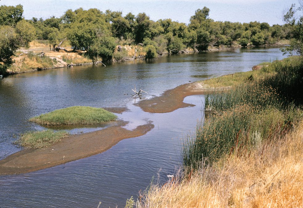
Two days prior I had driven across the San Joaquin River via the Airport Way bridge where I spied a growing sand bar in the walled in channel just 10 miles south of Manteca. The water was more murky than clear. Due to flows propped up by dam releases primarily from its tributaries of the Tuolumne and Stanislaus rivers, the San Joaquin near the depth of summer almost looked mighty.
You can stand on the water’s edge just a few hundred yards from the Manteca Sportsmen’s Club nestled against the levee along Airport Way and, if you’re lucky, you can hear the river whisper to you as its large and mature flow makes its way behind Mossdale Crossing where it splits into the Old River and newer river channel.
That contrasted sharply with what I heard as I walked to where the San Joaquin River middle fork started in earnest from water that had flowed from Thousand Island Lake and into Garnet Lake. There you could carefully step across the water as the river eagerly picked up speed rushing over an incline of rocks long and steep enough to qualify as a low key waterfall while making a joyous sound that only imperious youth can create.
As I lounged in the sun on a massive outcropping on the lake’s edge I was 105 miles as the crow flies from Manteca where the San Joaquin has punched major holes 11 times since 1929 in levees man has thrown up to protect fertile farmland and now growing cities during abundant periods of snowmelt and rain.
The insanity of man’s attempts to tame the San Joaquin are rooted in the forces that spawned Thousand Island Lake from the once icy underbelly of a glacier that retreated long before even those we identify as indigenous Californians walked along the river 8,000 years ago.
The current course of the present-day San Joaquin was shaped well into the Tertiary Period that ended 2.6 million years ago. It was further reinforced by glaciers that once covered 1,100 of the 1,760 square miles that comprise the San Joaquin River Basin.
Man’s ingenuity has been broken by the San Joaquin 11 times in 91 years, a period of time that is similar to the fine decomposed granite I had brushed away from the rock to rest my bones when it is compared to the whole of Mt. Banner looming on the western horizon.
We tend to take the San Joaquin River for granted except for when we take forays to fish and play in its waters or are loading up the car with valuables to be ready to flee on a moment’s notice should one of the levees inch toward failure during high water flows.
The 1,760-square foot San Joaquin River Basin that the San Joaquin River and its web of tributaries provides with snowmelt helps support what is arguably the most productive agricultural region on earth. The bulk of California’s nearly $50 billion farm production, more than twice that of the nearest state, is produced in the San Joaquin Valley. The valley grows more than 400 commodities as well as two-thirds of the nation’s fruits and nuts.
The ability to feed people has come at a great cost to the San Joaquin River that is among the most heavily dammed and diverted rivers in the West.
Up until a decade ago, a 150 mile segment of the San Joaquin River below the Friant Dam to just before the Merced River joins it five miles northeast of Merced frequently ran dry in the summer and fall.
Diversions were so high that during the 50 years prior to 2010 much of the river south of Merced would go dry.
That started to change a decade ago when an agreement between various agencies to reduce diversions once again made it possible for snowmelt that leaves Thousand Island Lake to possibly make it as far as the Airport Way bridge south of Manteca.
The vast majority of the flow we see pass by rural Manteca and under Interstate 5 comes from the Stanislaus, Tuolumne, and Merced rivers.
Water flowed year round as late as the mid-19th century without benefit of manmade storage thanks to groundwater seepage from what was once California’s largest natural body of freshwater — Tulare Lake. At one point 50 percent of the San Joaquin River’s summer flow that passed what is now rural Manteca and Lathrop came from Tulare Lake groundwater seepage.
Tulare Lake was the largest freshwater lake west of the Mississippi River and the second-largest freshwater lake entirely in the United States based upon surface area.
It at one time covered 690 square miles as recent as 1868. That was after a massive flood in the Great Central Valley and before man started heavy diversions of rivers and streams feeding the lake to help create massive farms and supply water to cities.
How a river basically was allowed to disappear for long periods of time over half a century had a lot to do with where it ran dry in the middle of an intense farm region off of the beaten track. It was out of sight and therefore not on the minds of most people.
Once the San Joaquin River breaks free of the Sierra public access is limited.
Ironically what may help change the stepchild status the San Joaquin River has suffered in the shadow of the mightier and longer Sacramento River whose 400 miles drains much of the north state and its namesake northern portion of the Great Central Valley is an 11,000-home planned community.
River Islands at Lathrop when completed will offer unparalleled access to the San Joaquin River via an 18-mile loop trail on levees surrounding Stewart Tract while the Old River splits off from the main channel.
The Cambay development firm is committed to restoring “benches” — flat areas below the levee on the riverside that flood in high water. It will allow the restoration of trees, fauna, and wildlife that levees largely displaced on the water side.
It will create a situation where more people can easily access the river, walking alongside it from above while taking in the sights.
The more people who appreciate a river the more allies it has in the never-ending struggle to balance the needs of its ecological system with that of civilization.
The San Joaquin helps fill the stomachs of countless people. It also helps feed the souls of those that hike to see its origins in the high Sierra and as it makes it way down to Friant Dam that at 520,500 acre feet is the 18th largest reservoir in California. By comparison New Melones with 2.9 million acre feet on the Stanislaus River that helps support the San Joaquin River is the fourth largest.
Glimpses of what a levee-less San Joaquin River looked like before 98 percent of riparian oaks woodlands were removed for farming and massive dirt berms were put in place can be seen while walking along the Stanislaus River at Caswell State Memorial Park south of Manteca and west of Ripon.
For now the best way to see the river in a different light than a restricted stream between levees once it leaves Friant Dam and until it reaches Suisun Bay is to see it from where it starts its 366 mile trek free of the torturous constraints put in place during the past 150 years.
As impressive as the sun setting on the river as it serenely flows past Mossdale Crossing in Lathrop may be nothing beats the reddish cast on Mt. Banner sparkling with areas of glacial ice and snow on a mid-July evening as Thousand Island Lake creates a melody from clear rippling water as a cooling breeze ushers in nightfall in one of the most stunning palettes Mother Nature created in the Ansel Adams Wilderness.