Spikes Peak is not the highest point in the Diablo Range.
It maxes out at 1,927 feet.
But for access from the 209 it tops the king of the range — San Benito Mountain at 5,421 feet.
And when it comes to solitude it beats the mountain range’s most namesake peak, Mt. Diablo at 3,371 feet, hands down.
Spikes Peak is part of Pacheco State Park adjacent to — and immediately west — of San Luis Reservoir.
If you’re looking for solitude, a chance to enjoy the outdoors, take in relatively pristine vistas and get a bit of exercise in while social distancing then Pacheco State Park is the answer.
My most recent visit was the first Sunday of 2021, Jan. 3. The park is open for day use only for hiking and equestrian use due to the pandemic.
Google “Pacheco State Park” to get any updates for changes regarding uses such as camping. Do not travel to Pacheco State Park — or any park for that matter — if you are sick or someone in your household is sick. That is the State of California’s edict as well as common sense.
Masks are required when you are within six feet of anyone.
I didn’t need to wear one all day. During some 12 miles of hiking in less than five hours with plenty of stops to watch hawks in flight and to take photos, I encountered no one else. There were two separate solitary hikers I caught a glimpse off on two different trails that were lower than where I was at.
When I pulled into the parking lot there was only one car there. And just before I got back to my car, a different vehicle was pulling out. It’s quite possible that between 11 a.m. and 5 p.m. Sunday there were only three people on 28 miles of trails. Now that’s social distancing.
It was my third trip to Pacheco State Park in the past four years. Every time it was in January. And each time it was for my inaugural hike of a new year.
On the previous trips I never encountered more than a dozen people.
Visitation does pick up in the early spring. And according to a couple of horse riders I talked with two years ago, it is the best kept secret in the region for equestrian use.
Keep in mind no dogs are allowed.
Given Pacheco State Park was carved out of a Mexican land grant in 1841 and is still used for cattle grazing today in the winter and spring, a large share of the 28 miles of trails are wide enough for a pickup. That should give you an idea of the trail surface. Other trails that crisscross the accessible portion of the state park were created by the repeated pounding of hikers.
That said you need to pay attention to trail markers and how they relate to the trail map that you can download and print from the park’s webpage or snap a photo of with your smartphone.
I got a bit adventurous this trip and took a wisp of a trail that after two tenths of a mile ended. While it is hard to get lost in the park as all you have to do is head north if you get off trail, doing so will send you into some steep areas you might prefer to avoid.
The best way to describe the Pacheco State Park is hilly. The flat stretches are fleeting and far between. Most hiking websites rate all the trails as moderate. That’s a fair assessment. There are a number of loop trails you can do from the parking lot that range from 3.8 miles to 10.5 miles. You can also do what I did which is combine parts of loops with the largest loop. There are 15 named trails that are marked. On a previous trip I included part of Windmills Road that is more a real dirt road designed to service the windmills above San Luis Reservoir than cattle ranch roads.
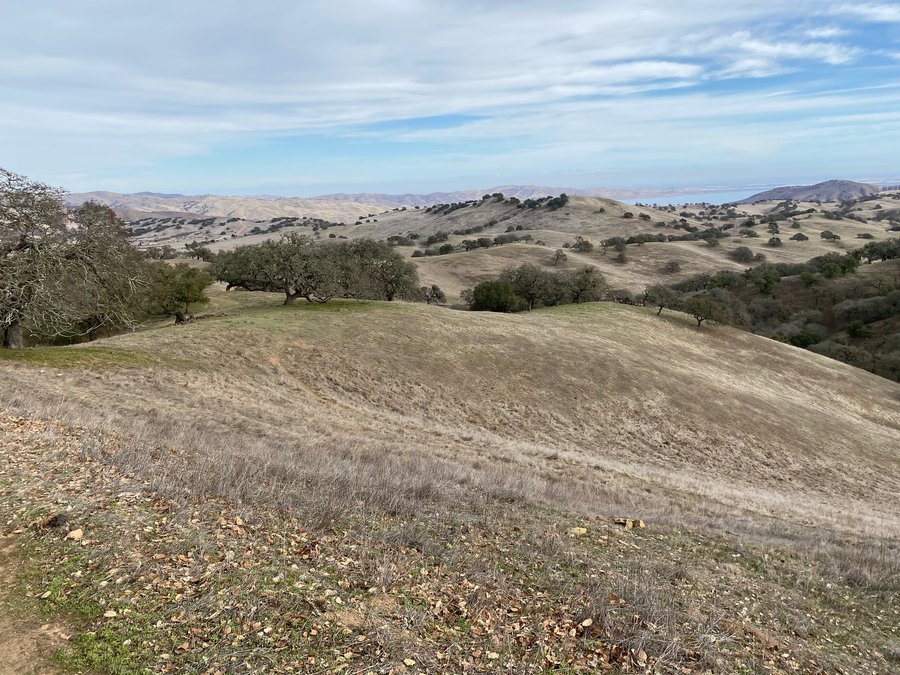
The scenery is classic rolling hills dotted with California oak. On previous January trips it was windy, wet and the grass was starting to turn green with a few early California poppies in bloom.
This time around, the park was still in winter gray and there was no green in sight.
That’s a good thing as it means the green is coming later this year that will push the peak of the wildflowers season into March.
I did, however, like what I saw. Oak trees in January are always devoid of leaves. But there was something striking about twisted trunks — with more than a few bent parallel to the ground — topped with bare branches set against a palette of grays, charcoals, and browns against a dreary cloudy ski as opposed to rolling hills of green behind them.
This time around besides cows I was able to see a few hawks. On previous hikes I’ve also seen golden eagles.
If you get lucky you’ll spy tule elk. Pacheco State Park also will occasionally have deer, bobcats, and coyotes.
Once you hike south into the park away from the entrance and the background noise of Highway 152, the only thing you’ll hear most of the time is the sound of your footsteps between the occasion sound of flapping wings of a hawk and the prerequisite mooing when one of the cows you pass decides to not stay silent.
It didn’t happen Sunday because the wind was virtually non-existent, but one of the coolest sounds at Pacheco State Park is the “whooshing” of the wind mills on the southeast corner of the accessible part of the state park. You can come within several hundred feet of the wind mill farm that generates enough electricity to power 3,600 homes.
Most trails offer stunning views of the San Joaquin Valley while Spikes Road Trail offers views of both the San Joaquin and Santa Clara valleys.
Pacheco State Park was part of the original 1841 land grant of 48,821 acres (11 square miles) the Mexican government gave Francisco Pérez Pacheco. The state condemned a large chunk of it to create San Luis Reservoir that at 2.04 million acre feet is the fifth largest reservoir in California. In comparison, New Melones Reservoir at 2.4 million acre feet is the fourth largest reservoir in the state.
The 6,890 acres that constitute the Park was donated to the state in 1992 by Pacheco’s great-granddaughter. Only the 2,600 western most acres are currently accessible to the public.
Pacheco State Park is located on Dinosaur Point Road accessed via Highway 152.
The day use fee is $10 per vehicle and is paid via the honor system.
Pacheco State Park is open daily from 8 a.m. to sunset year round.