
As “thirteeners” go in California, it is only ranked 137 out of 149.
But Mt. Dana is arguably the “every man’s” thirteener assuming you are in decent shape.
“Thirteeners” refers to mountains with peaks between 13,000 and 14,000 feet. In addition to 149 thirteeners California has a dozen “fourteeners” — peaks over 14,000 feet – including two that do not require climbing skills and multiple day backpack trips to their summits.
There are a number of reasons that make Mt. Dana unique.
*From here you can literally drive to the trailhead without leaving Highway 120 (that is Tioga Road through Yosemite National Park).
*You can hike it as a day trip — roughly a three hour drive up and a three hour drive back with a four to six hour hike.
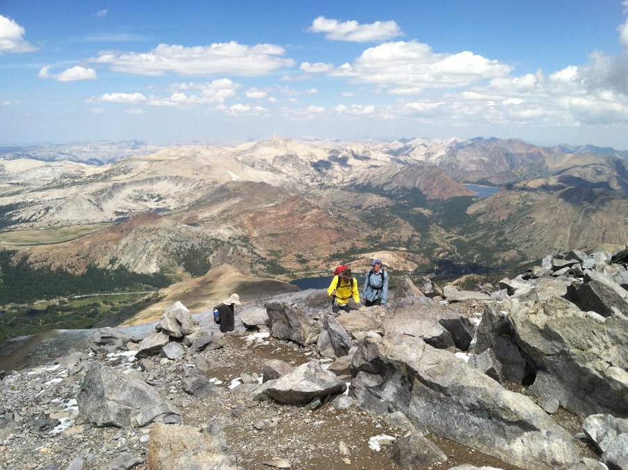
*At 13,045 feet it is the second highest peak in Yosemite National Park as well as the 209 topped only by Mt. Lyell some 66 feet higher.
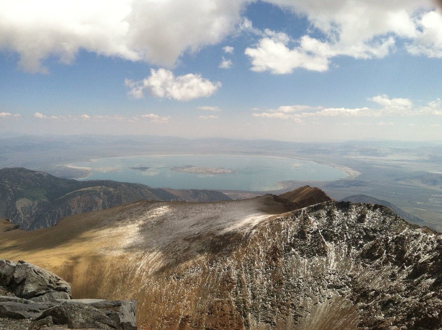
*It is a moderately hiked route that leads to spectacular views at the top.
The 4.8-mile round trip trail starts on the south side of the road at 9,624 feet. It goes through meadows and forests populated with small lakes (about half have dried up as summer has arrived). After a series of switchbacks some 1.5 miles and 1,500 feet into the hike you come across a relatively flat stretch before hitting what appears to be nothing but rocks to cover the remaining 1,000 or so feet.
There are various ways to reach the top but the easiest is a clearly worn path that makes its way through the rocks with the help of occasional cairns or piles of rocks placed by other hikers to help serve others as guideposts to help them stay on the route.
The views on the way up are impressive. The panorama at the top is stunning. To the east and 5,500 feet below is Mono Lake. From there a turn to the south takes in the Long Valley Caldera — one of the largest calderas on earth that are created with the eruption of super volcanoes — and Glass Mountain covered with its black volcanic glass-like rock, endless other peaks such at Mt. Gibbs, and Cathedral Peak in Yosemite, and as you complete the loop turn you can make out Highway 120. And in each direction you look there is mountainous vastness whether it is the Great Basin to the east or the imposing Sierra — John Muir’s beloved Range of Light — in all other directions.
Each time I spend a half hour at the summit soaking in the view that defines inspiring. The last trip included a nice 15-minute nap snuggled among rugged rock as I drifted off gazing at Mother Nature’s 760,000 year-old creation that’s one of the oldest lakes in North America — Mono Lake.
There is a Yosemite Park entrance fee of $35 per vehicle. Currently you need to make a reservation by going on line at recreation.gov. There is a $2 processing fee. If you have an annual Yosemite pass ($70) or either an annual national parks pass or senior lifetime pass for those 62 and older (each are $80) you will pay a discounted fee of $2 but will need to show your pass at the entrance station.
Mt. Dana is on the list of six peaks I’ve hiked multiple times because the views are that impressive. I plan on heading up Mt. Dana this summer for the fifth time.
If you end I liking Mt. Dana
then consider the state’s
two walkable ‘fourteeners’
Once you’ve done Mt. Dana and if you liked the views and challenge, there are two walkable fourteeners you can tackle — Mt. Whitney that at 14,505 feet in the eastern Sierra is the highest point in the contagious 48 states and White Mountain.
White Mountain at 14,252 is the tallest peak in its namesake mountain range east of Big Pine and the third highest peak in California.
White Mountain is actually drive-able to the top — if you are a researcher — where there is a summit weather station.
It does require taking a primitive road that can be done with a high clearance two wheel drive vehicle by taking it easy to reach the trailhead at Bancroft Gate. The drive to the trailhead will take you past turnoffs leading to the oldest living things in earth: bristlecone pines. The oldest bristlecone is known as Methuselah at 4,853 years.
As hikes go, it is moderate but can be a slog. That’s because the 15.2 mile round trip is along a primitive road basically with no trees and completely exposed to the elements.
The only living things you’ll encounter that isn’t hardy vegetation or insects such as ants or flies are marmots.
They are basically large squirrels that can reach up to 28 inches in length.
The best time to hike is April to August. Keep in mind there is no water and because of its exposure and elevation it is subject to the occasional summer afternoon thundershowers just like the high peaks in the eastern Sierra.
Unlike White Mountain, Mt. Whitney requires a permit.
The lottery for this year is over but you can go online for the few permits that are still available.
The permit requirement is strictly enforced along the trail by rangers who hike it daily. I’ve been up to the 14,505-foot Mt. Whitney summit four times, and three of those times I’ve seen hikers turned back due to not having permits.
The hike is do-able in a day if you start at 2 a.m. The Mt. Whitney trailhead starts at Whitney Portal at 8,360 feet, some 13 miles east of Lone Pine.
The trail from the portal is well-maintained and not overwhelming. It is considered strenuous because for those who do it in one-day it means a net gain of 6,137 feet – twice the elevation of Mt. Diablo — and a 21.4 mile round trip.
The only drawback to the hike as far as I’m concerned is the people. It is limited to 100 a day for day use and 60 a day for overnight use because of the sheer number of people who want to tackle the summit.
One last thing about Mt. Whitney: If you can’t get a trail pass this year to access the summit trail, you can still enjoy a pleasant hike out of the Whitney Portal where there is camping and even home rentals. You can go a bit up the trail but not far.
Instead of doing that, though, I’d take the trail out of Whitney Portal and make the 11.2 mile round trip to Meysan Lake at just above 11,000 feet. It has a 3,500 foot elevation gain and it can be done in 7 to 10 hours.
Besides the fact there were only a handful of people we encountered on the trail, Meysan Lake gives you a stunning taste of what the world is like above the tree line at 11,000 feet in the Southern Sierra.
Personally the scenery is better than on the Mt. Whitney trail and you don’t have the feeling of being stuck in rush hour foot traffic. It is so peaceful that it makes my list of the best five places to nap as an excuse to go hiking on a trail that gets you a minimum of 2,000 feet in elevation gain.
Of course you can’t say that you hiked to the highest point in the contiguous 48 states but it is so worth the drive that I’m thinking about building my summer hiking trip this year to the Eastern Sierra around it, including the hike as one of my six ventures.