
By DENNIS WYATT
209 Living
POINT REYES NATIONAL SEASHORE — Walk on the 71,028 acres the Point Reyes National Seashore, you are walking on the earth of a future island.
The relatively young geological formation we've dubbed California is moving in opposite directions slowly but surely year in and year out.
The national seashore is west of the San Andreas Fault and will eventually be torn away from the rest of California. The nearby Tomales Bay made its last big headway adding to its southern reach during the 1906 San Francisco Earthquake.
What makes the two hour, 107-mile journey from the 209 worth the trip isn't the geological wonder of different soil and terrain than what you will find immediately to the east of the San Andreas Fault in the rest of Marin County. The shoreline and surrounding land has been compared to the Cape of Good Hope in South Africa.
It is the sweeping views, the rugged and relatively pristine shoreline, the variety of hikes including being able to walk near herds of tule elk, and the whale watching.
What draws the most people to Point Reyes between now and mid-March is the ability to watch gray whales migrating past the point.
Buses ferry visitors at $7 a pop from the Drakes Bay parking lot to the lighthouse from now through mid-April as well as on weekends and federal holidays between 9:30 a.m. and 3 p.m. You can drive there at other times.
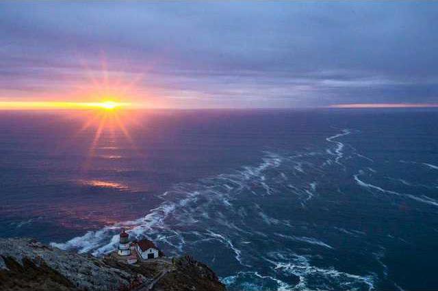
Once at the lighthouse parking lot, visitors descend down some 300 steps (the rough equivalent of 25 stories) to the historic lighthouse. From that vantage gray whales are fairly easy to spot as this time of year as they hug the California coast while migrating.
What makes the Point Reyes headlands ideal for watching California gray whales — that engage in the longest migration of any mammal swimming 10,000 miles from the waters of Alaska to the shallow lagoons of Baja California — is the fact it juts 10 miles out into the Pacific Ocean. Sometimes the whales swim close to shore, other times they are farther out. That is why binoculars can come in handy.
Also high on the list of spots in California to spot whales is Point Reyes’ Chimney Rock — the eastern spur of the Point Reyes headlands. It requires a 1.7-mile round trip hike to reach. You must tame the shuttle bus this time of year, though, due to the heavy visitation to see whales migrate The hike takes you along the ridge crest of a narrow peninsula offering stunning views of Drakes Bay and the rugged coastline to the south east.
Chimney Rock can be windy, foggy and cold so be prepared. While there are restrooms at the parking lot there is no water. There is no beach access along the trail as the rocky cliffs drop steeply to the water’s edge. If you wait to go until spring be prepared for an incredible showing of wildflowers along the trail.
If you want to take in elephant seals, be prepared for a moderately steep but short hike to the elephant seal overlook via a paved driveway and then two-tenths of a mile trail.
There are more than 150 miles of trails. While my favorites are the Sky-Bear Valley Loop, Woodward Valley Loop, Bear Valley Trail and Tomales Point Trail ranging from 9.5 to 13 miles with some fairly decent elevation games — not more than 1,300 feet —taking between three and six hours depending upon your ability, there are eight popular hikes under an hour and seven that can take you between one and three hours.
The favorites among the shorter hikes are the Earthquake Trail (0.6 miles) and the Limantour Spit Trail (2 miles).
The Earthquake Trail loop explores the San Andreas Fault Zone and has plenty of interpretive signs explaining the geology. The trail is by the Bear Valley Visitors Center. It isn’t much of a hike from a physical standpoint but if you’re a Californian you’ve got to be fascinated by quakes.
The Limantour Spit Trail is a 20-mile drive from Bear Valley Visitors Center. Bring binoculars and a field guide to birds as the mudflats you’ll see and the sandy beaches of Drakes Bay are rich with various bird species. Harbor Seals also poke their heads out of the water fairly frequently.
My absolute favorite Point Reyes hikes are Tomales Point Trail (9.5 miles) and Alamere Falls (13 miles) for two very different and impressive reasons.
Tomales Point doesn’t just offer views of Tomales Bay, Bodega Bay, and the Pacific Ocean but you will come across plenty of tule elk that once numbered in the tens of thousands when they roamed the Great Central Valley. The last stretch of the trail is overgrown meaning long pants and long sleeves are in order. As you near the point it can get pretty cold and windy. Fog can also pose a challenge. The start of the trail is a 40-minute drive from Bear Valley.
Alamere Falls is a stunning water drop some 30 feet down onto the south end of Wildcat Beach. The hike needs to be made during low ride.
Information on the hikes mentioned and others are available at the Bear Valley Visitors Center.
In the summer, the Point Reyes lighthouse is often enshrouded in chilly fog throughout the day while just an eighth of a mile away the temperatures can be in the mid-70s.
Point Reyes is not a national park per se as historic uses such as dairy farming still take place within its boundaries.
While there is a lot to savor at Point Reyes National Seashore, the favorite spot by far is Drakes Bay. A survey conducted in 2010 list Drakes Bay and other beaches at Point Reyes as the cleanest in California.
Drakes Bay offers a long beach that is a favorite for people soaking in the scenery, flying kites, enjoying picnics or just waking. There is a visitors’ center with bookstore and restrooms.
Back in the late 1950s, there was a plan to build expensive homes on the bluffs overlooking Drakes Bay which was discovered by the famous English explorer Sir Francis Drake in 1579. It was the event that ignited the movement to preserve Point Reyes as a national seashore.
The result has provided Californians with an opportunity to enjoy some of the most pristine seashore near an urbanized area on the planet.
And it’s just over two hours away from the 209.