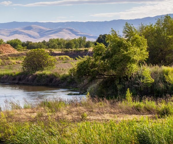
Tenaya Lake offers not just respite from the valley heat but it is also an easy-to-access slice of the quintessential high Sierra lake experience.
Unlike almost all of the 2,000 plus other lakes of glacial origins scattered along the 430-mile Sierra range, it does not require hiking mile upon mile to reach.
You can literally drive to its very edge on Highway 120.
Well, OK, not exactly.
That’s because the section of Highway 120 that passes through Yosemite National Park is technically not part of the state highway system.
It’s known as Tioga Road between the Crane Flat and Tioga Pass park entrance stations.
But it is still the same continuous ribbon of pavement that we call Highway 120.
So why Tenaya Lake, besides it being the most accessible and largest lake in the Yosemite front country?
It has sandy beaches.
It is 114 feet deep with crystal blue waters.
The snow melt that fills the lake makes swimming a cool treat.
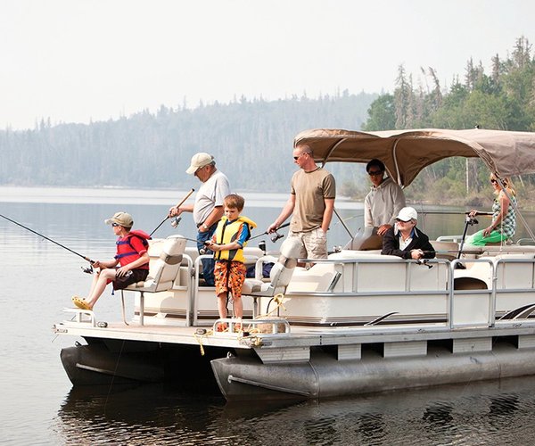
You can take in the majestic setting on paddleboards, kayaks, or canoes. No motorized boats are allowed.
The shores are ideal for picnics or simply an afternoon of R&R.
You can hike a 2.5-mile loop trail around the lake with no elevation gain.
And it also serves as a spectacular starting and ending point for hikes through the back country to Cathedral Lakes, Half Dome and my favorite vista above Yosemite Valley — Cloud’s Rest.
An argument can be made that Tenaya Lake — named for the last chief of the Yosemite Indians — is the most beautiful lake within the 1,169 square miles of the national park.
It is flanked by granite peaks and domes on three sides.
The letdown from being a true blue Sierra glacial lake setting is the fact Tioga Road (Highway 120) runs along its northern edge.
Most can easily overlook that given it is the reason you don’t have to hike six miles round trip or backpack to access it.
The lake is at 8,149 feet. That means on a 100-degree day in the valley, the temperature there won’t peak much above 80 degrees.
All of that combines to make Tenaya Lake arguably the best place to worship the sun in the 209 without being roasted like a Costco rotisserie chicken on most summer days.
And if you want to try and channel Ansel Adams with your smartphone, this is a good place to do it.
For a view you’d see on a postcard — that’s a prehistoric card-stock device that you shared memories with others far away by putting a stamp on the opposite side of the image and dropping it in the endangered species known as a mailbox that people over 60 used before the advent of Instagram — head to the west end of the lake.
There the view across the lake takes in soaring granite promontories that surround the 1.6-mile long Tenaya Lake.
The full loop hike is worth it.
In the spirit of full disclosure, besides walking along Tioga Road on the west side, it has a few inconveniences such wading across both the inlet and outlet.
It also requires a dab or two of Deet to fend off the mosquitoes at various times of the day.
For the best views with the least effort and just a few minutes of time, park near the western edge of the lake and then walk south along the shore there until you reach the lake’s outlet.
Now for a bit of interesting geology and such that includes a relevant bit of information about climate change.
You didn’t think this was just going to be a trip devoid of relevance, did you?
There are a few tree stumps that poke up from Tenaya Lake that tend to get overlooked.
The lodgepole pine remnants are between 600 and 1,000 years of age.
Why that is relevant is thanks to scientists who dabble in dendroecology, the study of tree rings using radio carbon dating technology.
Tree ring growth is directly tied to the moisture a tree takes in during a given year,
The ages of the Tenaya Lake tree stumps overlap generally with the Medieval Warm Period.
That’s when rising temperatures across the Atlantic led to settlers in Greenland, to plant vineyards in Britain, and increased food supply that enabled a doubling of Europe’s population.
Here in what today is known as the Southwest United States that includes most of California, the times weren’t so much fun.
During the same time frame there were two periods of extended drought — punctured by a year or two of above normal or average precipitation — that lasts more than a century apiece.
Lodgepole pines were growing where what is now the last upper 25 to 60 feet of Tenaya Lake that was dry ground back then.
Toss in the fact Tenaya Lake — as well as Half Dome and Yosemite Valley itself — was carved by glaciers and it is clear climate change per se has been around a lot longer than Greta Thunberg seems to believe and is clearly driven more so by the forces of nature than anything else.
And now for a bit of “bookkeeping”, so to speak.
Tioga Road has finally opened into the Yosemite high country after being cleared of snow and roads mostly repaired.
It makes it an ideal time to make the roughly 130-mile, three-hour drive from the 209 to bask in the Sierra high country. If you want to make a longer day of it, Yosemite’s version of an alpine heaven awaits just 12 minutes farther up the road some 7 miles to the east in the form of Tuolumne Meadows.
Given the heavy snow and conditions that existed at similar elevations earlier this month in the Eastern Sierra, that means you’re likely to witness what few see — Tuolumne Meadows in springlike glory.
Access to Yosemite National Park requires a $35 pass per vehicle that is good for seven days.
There are pit toilets at Tenaya Lake.
It goes without saying the window to visit Tenaya Lake is narrow.
Access on anything but foot or backcountry skis ends when the snow returns usually in November.
Also it should be noted after mid-October, no overnight parking is allowed at Tenaya Lake for those using it as a jumping off point for backcountry hikes.