
Altering control operations at New Melones Reservoir coupled with harnessing farmland for recharging has the potential to blunt — and almost negate — the near-term climate change impact on water supplies within the Stanislaus River watershed.
That’s the CliffsNotes conclusion of a set of San Joaquin Basin Watershed studies released earlier this month by the California Department of Water Resources.
Separate studies for the Stanislaus, Tuolumne, Merced, Calaveras and Upper San Joaquin rivers addressed flood managed aquifer recharge strategies.
The Stanislaus River Basin currently averages runoff of 360,000-acre feet of water.
The study projects that within the Stanislaus watershed by 2050:
* Hotter conditions will reduce annual runoff by 29,000-acre feet.
* The temperature shift also will require an additional 21,000-acre feet to sustain the current level of farming.
* Surface water supplies that would drop by three percent from the current average of 360,000-acre feet, meaning it would for all practical purposes, be unchanged.
* Groundwater pumping is expected to increase by 21,000-acre feet.
* Annual ground water overdraft would increase from the current 5,000-acre feet to 10,000-acre feet a year resulting in a six-foot drop on average east of the basin’s Corcoran Clay formation.
Flood risks overall would remain low over the next 25 years. The impact on ecosystems is also anticipated to be low.
More than 240,000 people in Manteca, Lathrop, Tracy, Oakdale, Ripon and Escalon rely on Stanislaus River surface water.
The watershed supplies 109,000 acres of farmland with irrigation water between the South San Joaquin Irrigation District and Oakdale Irrigation District.
That is in addition to ecosystems along the Stanislaus River.
To address the increased water demand and obtain groundwater stability mandated by state law by 2045, which requires no more water being taken from underground aquifers than is replenished in a given year, there are two recharge strategies being advanced.
* Streamlining the permitting process for diverting river flows to recharge groundwater when water flows in the river exceed certain levels. That would yield an average of more than 13,000-acre feet a year for groundwater.
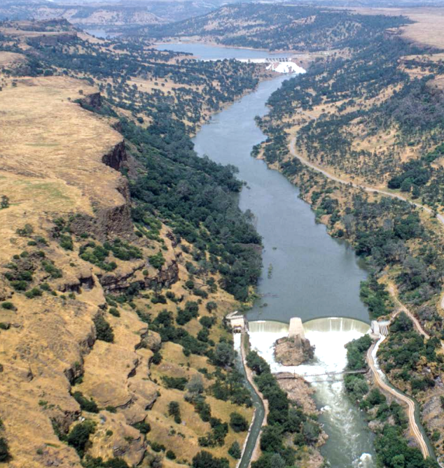
* Altering reservoir operations in tandem with downstream needs would effectively turn flood risk into a water source that could lead to 39,000 additional acre feet of recharge using water captured behind New Melones.
The change in operations also would reduce the intensity of peak winter flows and likely reduce off-channel salmonid habitats by 47 percent.
That said, in-stream salmonid spawning and rearing habitats would experience minimal change.
As a bonus, the change in operations would result in the creation of more than 960-acre days of new shorebird habitats in the transition area between the Delta and the Bay.
The operational change for New Melones would use one- to seven-day ensemble forecasts to inform reservoir flood releases in combination with recharging management. It would also reduce the maximum controlled flood release.
That has the benefit of potentially:
* Mitigating 100 percent of the climate change groundwater loss.
* Dramatically reduce the occurrence of flood flows above the operational channel capacity of the Stanislaus River from occurring in 23 percent of years to just one percent.
That would help ease flood risk on the San Joaquin River as it would reduce peak flows into it from the Stanislaus River at Vernalis near the Airport Way bridge south of Manteca.
Seepage and recharge
potential in SSJID, OID
The state study projected flood-managed aquifer recharge using the 862 miles of canals between the SSJID and OID from seepage could translate into 180-acre feet a day.
That breaks down to 135-acre feet via OID canals and 45-acre feet in SSJID canals when managed floodwater is released into the respective systems.
The potential for aquifer recharge via the canals is 4,500-acre feet.
The study indicated there are 45,817 useable acres in OID for recharging using managed floodwater flows and 40,016 acres in the SSJID.
Overall, the state identifies 103,537 acres that are useable for aquifer recharge.
The study is based on the projection there will be less snow in the higher elevations and more rain in the foothills and valley as the climate shifts.
As such, the snowpack will play a diminished role as a de facto reservoir.
The in-basin recharge would avoid all of the increased rainfall below New Melones from flowing into the Delta without benefiting the cities, farms, and ecosystems within the Stanislaus watershed.